Super typhoon Yagi to hit Gulf of Tonkin Friday night, drenching northern Vietnam
Super Typhoon Yagi maintained its strength Friday morning with maximum wind speeds of 201 kph and is expected to enter the Gulf of Tonkin at night, lashing northern Vietnam with strong winds and heavy rains.
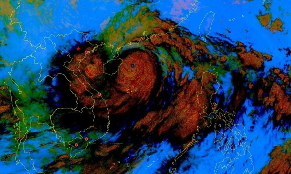
The National Center for Hydro-Meteorological Forecasting (NCHMF) reported that as of 7 a.m. Friday, Yagi was in the northern waters of the East Sea, approximately 150 km from China’s Hainan Island and 600 km from Quang Ninh Province, home to Ha Long Bay. The typhoon continues to maintain its peak wind speed of 201 kph, classified as a super typhoon, and is moving westward at 20 kph.
 |
|
A satellite image of super typhoon Yagi on Sept. 6, 2024. |
Yagi is expected to shift slightly southward, likely making landfall on Hainan Island on Friday afternoon instead of the Leizhou Peninsula of China as previously forecasted. By Friday night, the storm will enter the Gulf of Tonkin with wind speeds ranging from 134 to 166 kph, veering northwestward at a speed of 15-20 kph.
Due to its rapid southward movement, Yagi's landfall in Vietnam is anticipated earlier, likely around midday Saturday. The eye of the super typhoon is expected to first strike between Quang Ninh and Hai Phong, with wind speeds ranging from 89 to 133 kph.
The storm will then move deeper into northeastern Vietnam, bringing winds of 39-74 kph until evening.
Meteorological agencies report varied forecasts. The Japan Meteorological Agency estimates Yagi's wind speed at 198 kph, expected to decrease to 126 kph as it enters the Gulf of Tonkin. The Hong Kong Observatory predicts the storm will maintain winds of 185 kph in the Gulf, while the U.S. Navy forecasts a maximum wind speed of 220 kph, which is expected to reduce to 148 kph as the storm enters the Gulf of Tonkin.
According to the NCHMF, starting Friday night and into Saturday morning, coastal areas from Quang Ninh to Thanh Hoa will experience winds of 39-49 kph which will intensify to 62-74 kph. Areas near the storm’s center could see wind speeds of 89-102 kph. Inland areas may experience winds of 39-49 kph, while coastal regions from Quang Ninh to Thanh Hoa could see waves of 2-3 meters, with waves near the storm’s center reaching 3-5 meters.
Yagi is expected to bring heavy rain to northern Vietnam and Thanh Hoa from Friday night until Monday morning. Rainfall is forecasted to range from 100-350 mm, with some areas receiving over 500 mm. The heaviest rain will occur in northeastern Vietnam, concentrated on Saturday. In northwestern Vietnam, rain will begin Saturday evening and continue through Sunday night. Low-lying and urban areas may experience flooding, with potential flash floods in small rivers and streams, and landslides possible on slopes.
In response to the storm, four airports will be closed on Saturday: Noi Bai in Hanoi from 10 a.m. to 7 p.m., Tho Xuan in Thanh Hoa from noon to 10 p.m., Van Don in Quang Ninh from 4 a.m. to 4 p.m., and Cat Bi in Hai Phong from 4 a.m. to 4 p.m.
Hai Phong, Quang Ninh, Thai Binh, Nam Dinh, and Nghe An are expected to enforce sea bans starting Friday afternoon, while Ninh Binh already implemented the ban from Thursday afternoon.
Source: VnExpress
 Bắc giang


Reader's comments (0)