Storm Nesat strengthens as it heads for Vietnam
At 7 a.m., the storm's maximum wind speed was 133 kph, 16 kph strong than what was recorded on Sunday, according to the National Center for Hydro-Meteorological Forecasting.
 |
|
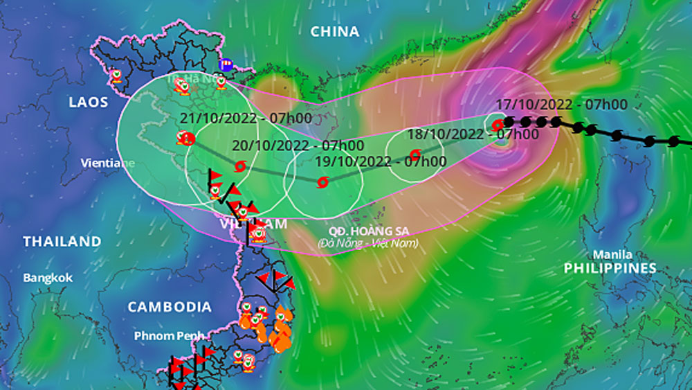
A map that predicts storm Nesat's trajectory and areas of effect. |
Within Monday, the storm would move west-southwest at 15 kph and may get stronger over time.
By 7 a.m. Tuesday, the storm would be 270 km to the north-northeast of the Paracel Islands, the center anticipated.
Nesat would retain its trajectory and strength, and by 7 a.m. Wednesday, it would be about 200 km to the north-northwest of the Paracel Islands.
The Japan Meteorological Agency said storm Nesat would reach its peak strength, with a wind speed at 145 kph, on Tuesday, before gradually weakening to 65 kph as it enters the waters of central Vietnam.
The Hong Kong Observatory predicted that Nesat's peak wind speed would be 155 kph, before weakening to 85 kph as it moves closer to the shoreline.
Nguyen Van Huong, head of the Vietnamese center's weather forecast department, said there are three scenarios predicted for Nesat in the East Sea. The first case is the storm will meet a cold spell from the north and weaken off the central coast before devolving into a tropical depression upon making landfall.
The second scenario is the storm will meet a weak cold spell before entering the central coast with winds of 75-102 kph.
The third scenario is that it will move to the south of China's Hainan Island, meet a strong cold spell and weaken and break apart at sea.
On Sunday afternoon, the National Steering Committee for Natural Disaster Prevention and Control has requested localities from the northern province of Quang Ninh to Khanh Hoa in the central coast to closely monitor the storm, re-check the number of vessels, and prepare rescue plans to make sure people stay safe.
Nesat makes the sixth storm in Vietnam's waters this year.
It arrives shortly after Storm Son Ca raged the central region, bringing rainfall of up to 795 mm from 7 p.m. Friday to 6 a.m. Saturday that caused unprecedented flooding in Da Nang.
Source: VnExpress
 Bắc giang


Reader's comments (0)