Yinxing weakens near Vietnam's coast as new storm approaches
Storm Yinxing continued to weaken on Monday morning and is expected to degrade into a low-pressure area as it nears central Vietnam, while Typhoon Toraji has intensified and is projected to enter the East Sea.
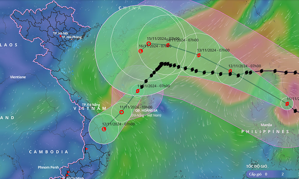
According to the National Center for Hydrometeorological Forecasting, as of 7 a.m. on Monday, Storm Yinxing lay centered in the northern waters of the Paracel Islands, with maximum winds reduced to 74 kph from 149 kph over the past 24 hours. Moving southwest at 15 kph, Yinxing is forecast to weaken into a tropical depression within the day.
 |
|
The predicted trajectory of storms Yingxing and Toraji in Vietnam's waters. |
By 7 p.m., the tropical depression is expected to produce winds of 39-49 kph in the waters off Quang Nam and Binh Dinh provinces, continuing to weaken further.
Typhoon Toraji, located in the eastern seas near Luzon Island in the Philippines as of Monday morning, has strengthened to maximum winds of 133 kph, up from 102 kph on Sunday morning, and is moving west-northwest at 20 kph. The meteorological agency anticipates Typhoon Toraji will enter the East Sea later on Monday, becoming the eighth storm in the waters this season.
By 7 a.m. Tuesday, Toraji is expected to maintain its course and speed over the northern East Sea, with winds decreasing to 102 kph.
The Japanese Meteorological Agency predicts that Yinxing will weaken to 65 kph upon reaching the waters off Quang Nam and Binh Dinh, while Toraji is likely to head toward China's Hainan Island with winds around 90 kph. The Hong Kong Observatory has ceased forecasts for Yinxing, while its projection for Toraji aligns with Japan's, expecting winds of approximately 105 kph.
Nguyen Van Huong, head of the Weather Forecasting Department at the National Center for Hydrometeorological Forecasting, said Yinxing is rapidly weakening due to low sea surface temperatures in the western Paracel Islands, which are below 26 degrees Celsius, limiting energy for storms.
Additionally, cold, dry air is covering the area, reducing humidity from ground level up to 1,500 meters, which restricts cloud formation. Furthermore, Typhoon Toraji, located about 1,200-1,400 kilometers from Yinxing, is creating a double-typhoon interaction, pushing Yinxing further southward.
Due to the impact of Yinxing, areas from Thua Thien Hue to Binh Dinh are expected to receive 70-150 mm of rainfall on Monday afternoon, with some areas seeing heavy rainfall exceeding 100 mm in a six-hour period. On Tuesday, the Central Highlands is forecast to receive 40-90 mm of rain, with some areas accumulating over 180 mm.
Before Yinxing, Typhoon Tra Mi struck Thua Thien Hue and Da Nang on Oct. 27, bringing heavy rains to central Vietnam, resulting in eight deaths, 14 injuries, and damage to nearly 330 houses, over 1,200 hectares of crops, and the loss of 1,500 livestock.
Typhoon Yagi, Asia's strongest storm this year, hit northern Vietnam on Sept. 7, killing 299 people and leaving 34 others missing, causing damages estimated at VND81.5 trillion (US$3.31 billion) across the area as devastated export-oriented industrial hubs and tourist centers.
 Bắc giang










Reader's comments (0)