 Bắc giang

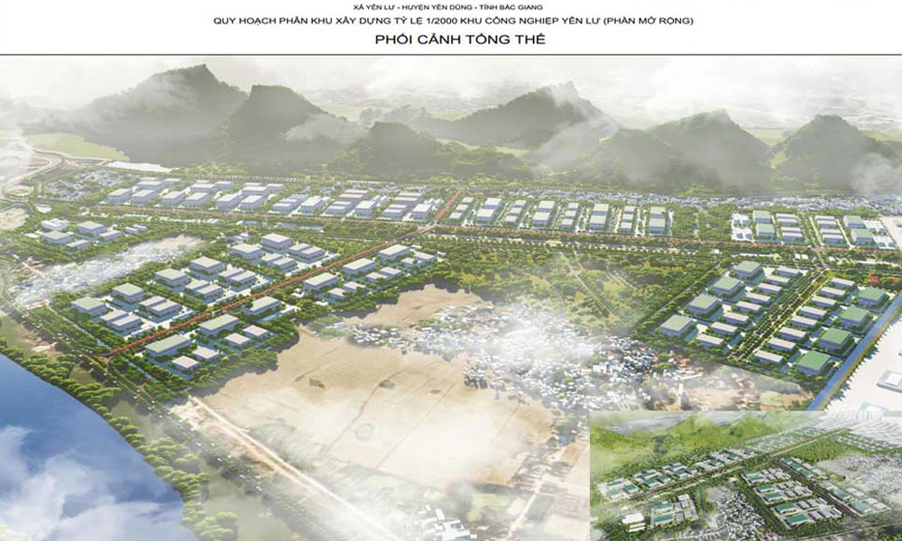
Bac Giang approves for adjusted general planning to build Bac Giang city by 2035, with a vision to 2050
Particularly, the area for locally adjusted planning is at the scale of about 45.7 hectares in Dong Son commune, Bac Giang city and Tien Phong commune, Yen Dung district. The adjusted planning area borders the residential area project in the heart of Dong Son commune to the North, the existing residential area and agricultural cultivation land in Dong Sau village, Dong Son commune, Bac Giang city to the South, the existing residential area in Chua and Soi villages, Dong Son commune, Bac Giang city to the East and the existing residential area and agricultural cultivation land in Thanh Cong village, Tien Phong commune, Yen Dung district.
 |
|
Illustrative photo. |
The general planning of Bac Giang city will be locally adjusted by 2035 with a vision towards 2050. The land use structure in the planning area (38.1 hectares) will be re-arranged and adjusted, particularly moving the green strips and water surface towards the Northeast to transfer this area into commercial land, close to the main route while adjusting part of mixed land for high buildings into low-rise residential land.
Regarding adjustment to the planning area of the subdivision No 3, Bac Giang city, Bac Giang province at the ratio of 1:2000, the land lots of K4-CX18, K4-CX19, K4- CX20 will be transferred into commercial land from the land use planning for green areas and water surface.
The land lots of K4-HH1, K4-HH2 and K4-HH3 will be adjusted into land for green areas, water surface and part of land for low-rise residential buildings from mixed land use planning. A part of the land lots K4-CX17 and K4-HH4 will be transferred from land use planning for green areas and mixed land into land for low-rise residential buildings and traffic purposes. The land lot K4-HH4 will be about 1.75 hectares after adjustment. The land lot K4-OCT2 will be adjusted from land for high-rise residential buildings into land for low-rise residential buildings with the sign K4-OTT.
The 2 land lots in the Northwest will be adjusted from land for low-rise residential buildings into land for high-rise residential buildings with the sign K4-OCT1. A part of the land lot K4-OCT1 will be adjusted from land for high-rise residential buildings into public land with the sign K4-CC.
Besides, the land use parameters of the land lots will be adjusted for maximum construction density and maximum floor area ratio in accordance with the National Technical Regulation QCVN 01:2021/BXD by the Ministry of Construction.


Reporter


Reader's comments (0)