 Bắc giang

Tropical depression intensifies into storm, to bring heavy rain to central Vietnam
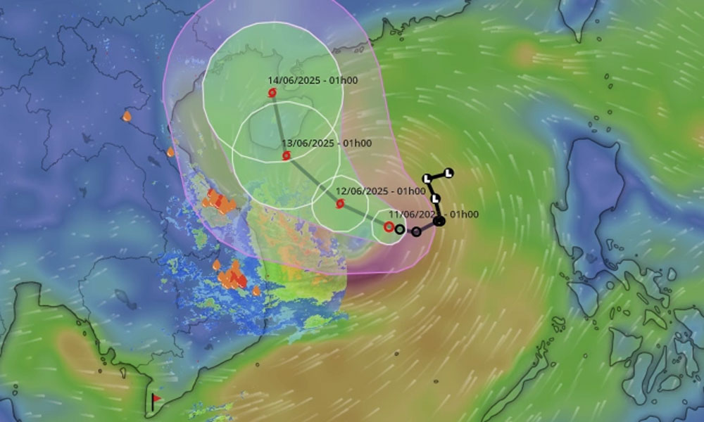
A tropical depression formed over the East Sea strengthened into a storm after one day on Wednesday morning and is forecast to bring prolonged heavy rainfall across central and south-central Vietnam.
Storm Wutip lay centered in the waters east of the Hoang Sa (Paracel) Islands, packing winds of 74 km/h at 7 a.m. Wednesday, and is forecast to move northwest at 5-10 km/h, according to the National Center for Hydro-Meteorological Forecasting.
 |
|
The predicted trajectory of a tropical depression in Vietnam's East Sea. |
The storm is expected to strengthen in the next two days, moving past the Paracels with 75–88 km/h winds on Thursday morning, and reaching the waters south of China's Hainan Island on Friday morning with winds of up to 102 km/h.
By Saturday morning, the storm is expected to move past Hainan and start to weaken.
The Japan Meteorological Agency forecasts that Wutip will hit maximum winds of around 90 km/h as it approaches Hainan Island, while The Hong Kong Observatory expects wind speeds to reach 110 km/h. Both stations forecast that the storm will not make landfall in Vietnam.
But central Vietnam should brace for widespread heavy rain, according to Vietnam's national forecast center.
On Wednesday, the south-central area may receive 30–80 mm of rain, with localized totals exceeding 150 mm. From Wednesday night through Friday, provinces from Quang Binh to Quang Ngai could see 100–300 mm of rain, with some areas surpassing 450 mm. The northern Central Highlands may receive 70–150 mm, with higher totals in some locations.
Lam also warned of the potential for extreme rain events, with over 200 mm falling within just six hours in some areas.
In addition to rain, the tropical depression is generating strong winds over the northern East Sea, including the waters surrounding the Hoang Sa archipelago and northern central East Sea.
Offshore areas from Quang Tri to Quang Ngai and the Gulf of Tonkin may experience winds of up to 74 kph, gusts of 89–102 kph, and wave heights of three to five meters.
In response to the developments, the Ministry of Agriculture and Environment on Tuesday issued an urgent directive to localities in the central, Central Highlands, and southern regions.
Authorities have been instructed to prepare for possible flash floods and landslides, inspect vulnerable areas, enhance monitoring and early warning systems, and mobilize rescue forces and equipment as needed.
This is the second tropical depression of 2025. The first formed on Feb. 12 in Vietnamese waters but did not develop into a storm.
In 2024, the East Sea recorded 10 storms and one tropical depression—consistent with the long-term average. Five storms directly affected Vietnam’s mainland.
The strongest, Typhoon Yagi, made landfall in Quang Ninh and Hai Phong, lashing Hanoi and becoming the most powerful storm to hit Vietnam’s sea in 70 years and its mainland in 30 years.
Meteorologists forecast that between now and August 2025, around five storms or tropical depressions may form in the East Sea, with about two expected to directly affect Vietnam’s mainland.


Reader's comments (0)